
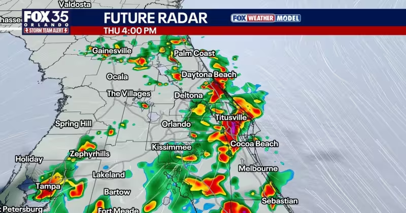
Miami weather is turning much wetter Thursday as tropical moisture pushes into Florida from the Caribbean, and forecasters have issued Weather Aware Days for the rest of the week and into the weekend. The change is expected to bring rounds of heavy rainfall, gusty winds at times and the potential for frequent lightning across Central Florida.
Thursday should begin with more cloud cover but mainly dry conditions, with temperatures near 80 degrees for the morning drive. Storms are expected to develop around the I-75 corridor around lunchtime, then move east and hover over the I-4 corridor from 2 to 4 p.m. By 5 to 8 p.m., the storms are expected to favor the I-95 corridor and coastline, lining up a wet evening commute as rain chances rise to 80 percent.
That is the kind of forecast that earns a Weather Aware Day label. The term means the weather pattern is expected to affect day-to-day life more than a typical day in Central Florida, and forecasters say that is exactly what is coming as tropical moisture stays locked over the region. Area-wide rain totals through Sunday are expected to reach 3 to 5 inches, with localized flooding becoming a concern pushing into the weekend.
The weather team is not expecting a significant severe weather threat, but the setup is still messy. Heavy rain and lightning can slow travel fast, and isolated storms may strengthen as they push toward the coast. FOX 35 said storms could be strongest in Brevard, Volusia and Flagler counties, and that a brief strong to severe storm cannot be ruled out, with gusty winds, small hail, heavy rain and frequent lightning among the main concerns.
The rain does not stop after Thursday. Chances are expected to stay elevated through the weekend and into early next week as tropical moisture remains over Central Florida, with another round of afternoon and evening showers and storms carrying a 70 percent chance of rain. Temperatures are expected to stay in the mid-to-upper 80s during the day and in the 70s at night, a pattern that will feel much more like August than early June.
The larger backdrop is simple enough. The moist air arriving now is the more reliable signal than any clearly developing tropical system, and forecasters say no systems are expected to form over the next 7 days. Hurricane season officially begins Monday, June 1, and runs through November 30, but for now the immediate story is local: more clouds, more downpours and a real flooding risk for roads and neighborhoods that can least afford it.
For drivers and commuters, the next few days are about timing and patience. The heaviest rain is expected to move through in rounds, not one clean burst, and that is often what turns an ordinary wet stretch into a disruptive one. With 3 to 5 inches of rain possible by Sunday and showers likely hanging around into early next week, Central Florida is headed into a stretch where the weather will shape the day more than the calendar does.