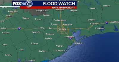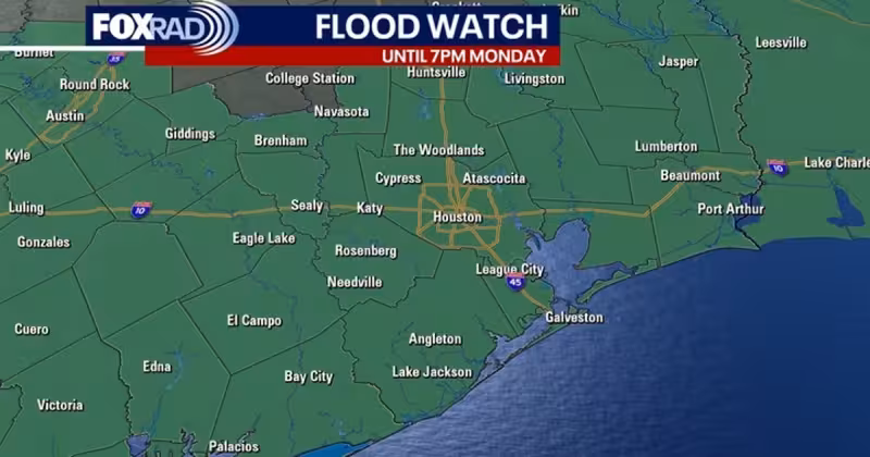
A Flood Watch is now in effect across just about all of Southeast Texas, including Harris County, and it runs until 7 p.m. Monday as Memorial Day weekend brings repeated rounds of storms. Houston will face the most active stretch from Saturday afternoon through Sunday morning, when models point to a big round of heavy rain.
The expected rain totals are enough to matter. Forecasters are calling for 2 to 5 inches through the holiday weekend, with isolated higher amounts possible, and Houston is at a level 2 out of 4 risk for street flooding on Saturday and Sunday. Friday should stay warm and humid, with highs in the mid to upper 80s and feels-like readings close to 90, while isolated to spotty afternoon and evening thunderstorms remain possible and the flood risk stays low.

The timing matters because Memorial Day weekend is one of the busiest travel and outdoor stretches of the year in Southeast Texas. Rain chances stay elevated through the holiday, and the setup becomes more concerning if an upper-level area of low pressure develops in north Texas, which would place Houston in a more favorable environment for heavier rain. Source guidance says flooding concerns will likely increase if that system forms, and the main weekend risk shifts from nuisance showers to repeated downpours that can overwhelm streets and low-lying spots.
There is also a separate severe-weather threat on Saturday. Southeast Texas is under a 1 out of 5 risk for a few strong storms, with the main hazards including gusts near 60 miles per hour and hail near quarter size. Memorial Day itself should be less active, with showers still expected but covering a smaller area than the previous two days. That should give the region a brief break, but not a clean finish to the weekend, because the Flood Watch stays up through 7 p.m. Monday and the chance of another heavy-rain episode remains on the table.
For now, the outlook is straightforward: the biggest concern for Houston Weather is not a single all-day washout, but repeated storms that can turn a holiday weekend into a flooding problem fast. If the heavier rain bands track as modeled, the streets will be the first place the danger shows up.